
CUMULUS CLOUDS
Summer clouds in Southwest Florida are spectacular. From fluffy puffs of white tinged with pinks and purples to dark rain clouds to stunning sunsets, our clouds display a myriad of sights and colors. Clouds are the visible aggregate of minute particles of water and/or ice that form when water vapor condenses in the atmosphere. While it would take a meteorologist to fully explain how clouds form (an intricate combination of water vapor, temperature, and dust particles), there are four basic types of clouds.
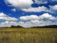
1. Cumulus clouds (from the Latin word for “heap” or “pile”)are the most common, and these fluffy white puffs can be seen scattered across our sky on any given day. These are generally fair-weather clouds. They are formed through a process called convection. The sun heats the Earth’s surface warming pockets of air. As this warm air rises, it expands and cools. The moisture in the air condenses at the exact altitude where the flat base of the cloud forms, while the buoyant updrafts continue to push the top upward into puffy mounds.
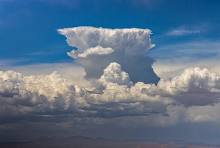
2. Cumulonimbus clouds (from the Latin word “nimbus” for rain) are dark cumulus clouds. They are tall, with flat bases and signal the presence of moisture and instability in the atmosphere. They form when towering cumulus clouds continue to grow and morph into massive storm clouds. They are the only clouds that produce hail, thunder, and lightning, and are frequently accompanied by torrential rain and sometimes tornadoes. Florida’s warm climate is ideal for the formation of these powerful storms, which is why it is important to keep an eye on the sky when in this sunny state. In Florida cumulonimbus clouds often build up in the morning and early afternoon as the land heats up, reaching their peak size and height in the afternoon. Often called thunderheads, these afternoon thunderstorms are a characteristic feature of the state’s weather.
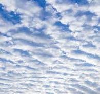
3. Stratus clouds are also common in Florida’s skies, more often in the winter months (dry season). They are low altitude clouds seen as a uniform layer across the atmosphere that can create a gray or overcast sky. They form when weak vertical currents lift a horizontal layer of air off the ground and it depressurizes due to atmospheric stability. This causes the relative humidity to increase, often creating light rain, continuous mist, fine drizzle, or “high fog.”
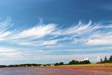
4. Cirrus clouds (from the Latin word “cirro” for curl of hair) are those high-altitude clouds that have a thin, wispy, feathery appearance. They are composed entirely of ice crystals and often look like hair-like strands or horse tails. While typically associated with fair weather, they can indicate an approaching warm front and portend that rain may arrive in 1 to 2 days. Cirrus clouds are more common in Florida during the winter months and often produce beautiful displays at sunset across the horizon.
NOTES:
Florida Smart
National Oceanic and Atmospheric Administration (NOAA)
Wikipedia
UCAR Center for Science Education